Local Space Astrology

Contents
Local Space Astrology uses a measurement system based on the local horizon and meridian, and was pioneered by Michael Erlewine.
Whilst the positions of the planets, as measured in right ascension and declination, or celestial latitude and longitude, remain almost constant regardless of the observers location, measurements of the planets’ azimuth and altitude changes dramatically according to where on Earth they are observed from. For example, a planet which is seen near the Northern horizon from some place on Earth will be near the Southern horizon from the opposite side of the globe.
The azimuths of the planets can be plotted on a chart known as a local horizon chart. Imagine that we are standing at our place of birth, at the moment of our birth, and turning in a full circle looking along the horizon. We can follow an imaginary line to each of the planets as they are placed in the heavens. Obviously as we imagine these lines running towards the horizon in the direction of the planets, we will see them running through certain cities regions and countries. These are the lines which appear on the local horizon chart.
If the local horizon chart is printed out onto a transparency, you can overlay this onto a map of your locality or region, although you must ensure that the centre of the chart is correctly centred at its true location on the map, and that the north/south axis of the chart is aligned with the north/south axis of the map. This will then show you where the local space lines for each planet go. The principle here is that if you follow any particular planetary line, then you are likely to encounter people, things or concepts which are related to that planetary archetype.
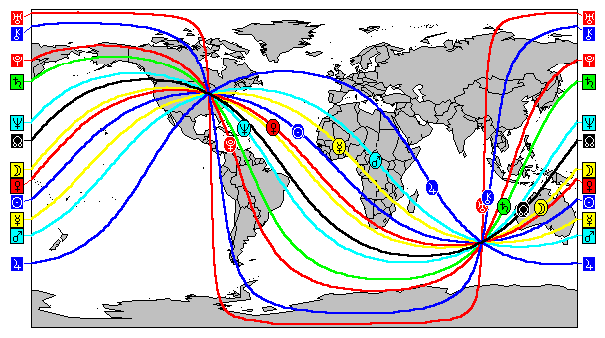
The same technique can also be used on maps of large areas, but it is important to note that on most map projections, the planetary lines will appear to curve rather than extending in a straight line. This is due to the fact that the Earth is actually round, and that the map is flat. However, Solar Maps takes account of this when local space lines are plotted onto a map, and if you view a map of the whole world, you will see that these lines extend around the whole globe and eventually back to their starting point. If you were to change the map projection option to view it as a globe, then it will become obvious that the lines are actually great circles around the Earth, and don’t really change direction at all, as they appear to do on the rectangular or Mercator map projections.
An Example
Consider the case of Ernest Hemingway (21 Jul 1899, 8:00 AM CST +6:00, Oak Park, IL, 41N54 87W43). He was renowned for restlessness, and travelled the world. Some particular examples from his life which are reflected in his local space lines are: his love of Europe and Paris (his Jupiter line runs through Europe near Paris); his work in patrolling for submarines off the coast of Cuba (his Pluto line runs across Cuba); his two aeroplane accidents in Uganda (very near his Mars line).
Although this example looks solely at the planet direction lines in Hemingway’s natal chart, it is also possible to use a relocated chart. This would be a reasonable thing to do if you have moved home, for example. If you do so, then you will notice that the planet direction lines for the relocated chart all converge on that chart’s relocated position, and if you have moved a great distance, the lines will form a completely different pattern, passing through different regions of the world.